 Live Music Archive
 Librivox Free Audio
 Metropolitan Museum
 Cleveland Museum of Art
 Internet Arcade
 Console Living Room
 Books to Borrow
 Open Library
 TV News
 Understanding 9/11
tv Red Eye FOX News October 30, 2012 3:00am-4:00am EDT
3:00 am

the forecasters and government leaders told us this would be a monster storm, and throughout the night and throughout the early morning hours sandy has been living up to those expectations. i am heather childers. >> welcome to a brand-new hour of hour special storm coverage. this system is currently classified as a post tropical storm, but don't let that fool you. forecasters say you -- say you shouldn'tly letting your guard down. twisters are likely to follow
3:01 am

restoring power to 500 million plus homes could take days or weeks. the storm is expected to touch 50 million people before it is over. our meteorologist is standing by with the latest. >> you mentioned that post tropical storm thing. we talked about this a few hours ago. there was a big messaging mess up with this storm. this storm went through a bit of a transition. the national hurricane center forecasted it would go through a transition from a hurricane which is a warm core storm. it is a storm that feeds off warm ocean water to a normal midlatitude storm. the storm that comes off of the coast, and because of that they decided that they were not going to issue hurricane warnings because it wouldn't technically, meteor logically be a hurricane. no hurricanes were issued even though we had a hurricane in the northeast. there will be a lot of push back against the way this was handled in a sense, and
3:02 am
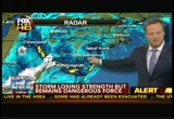
hopefully we should make sure our message is good for people to be safe. major problems here, and now all of the problems going on across parts of the mid-atlantic area, and it is very cold. cold air funneling in here. it is 44 degrees in washington, d.c. a lot of people without power, and now cold temperatures. you don't generally think of that after having a hurricane come ashore. it is still warm across parts of new england. because of that a tornado threat in that warm sector of the storm. here is the radar image. you can see the big storm and the big time rains going across jersey now and again toward eastern pennsylvania. a few more showers moving in across parts of long island and toward new york city and connecticut and still up toward maine. the worst part is that means the wint direction on the surface is out of the southeast, and it will continue to push water in toward this area of the new york harbor where we have seen incredible flooding across parts of manhattan and lower manhattan. big time snows across the area of the central appalachians. we have blizzard warnings
3:03 am
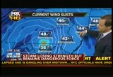
here. we have winds that are over 35 miles an hour and very heavy snow. it is reducing visibility. it will be causing drifting conditions. some areas will see well over two feet of snow by the time this is done and maybe even significantly higher than that. the bull's eye of snow is across west virginia. we will see it across tennessee, kentucky and maybe to the north georgia mountains. we will see snow across parts of ohio accumulating by the time this is done. we still have understand winds. winds are gusting across the coastal areas. take a look at these numbers. gusting at 62 miles an hour in cleavland. 53 miles an hour in columbus, ohio. 41 miles an hour in chicago. we will likely see some waves predicting around 20 to 22 feet or so. coming off these lakes with the strong winds, i think the better chance is across lake michigan. you should have a longer distance of water for the winds to go over. so these southern shores will see really incredible waves.
3:04 am

that's in chicago from a hurricane that came on shore and across parts of new jersey. absolutely unbelievable. guys? >> it really is. thanks very much. in manhattan, the lights are out and floods are a major problem. we have a look at the scene in hard hit lower manhattan. >> the storm has thrust much of lower manhattan into darkness. behind me is 39th street. you can look over my shoulder, and you can see that for the most part very few lights are visible. very few cars are on the road. most people wisely deciding to stay home. there have been a number of transformer fires throughout the city. in fact throughout the region. a few moments ago the fire trucks arrived on the scene. there is the smell in the air of something burning. meanwhile in lower manhattan there is massive flooding. there is record-breaking flooding.
3:05 am
we are told among the sites that are affected the world trade center site earlier, the governor toured that facility. it is likely the flooding there is going to cause a delay in the on going construction of the world trade center. also an area known as battery park city. that suffering severe flooding. it is home to some 10,000 new yorkers. a significant number of them over a thousand refused to leave despite the fact that there was a mandatory evacuation. now that area like much of lower manhattan suffering severe power outages. and lastly, one of the other locations affected by the lack of power, new york university hospital on the eastside. the back up power generators failed to operate, and because of that there were literally dozens and dozens of ambulances lined up outside
3:06 am

nyu hospital to take patients there elsewhere who are in need of treatment. much of the city still devastated by the storm. the subway system expected to be inoperable for several days. it will be several, several days at a minimum and perhaps much longer than that before the new york we remember turns to normal. back to you. >> david lee miller reporting from lower manhattan. thank you, david. >> the new jersey governor chris chris stey is -- chris christie is known for speaking his mind. the governor was not happy on monday with the way the atlantic city mayor handled things as the hurricane approached. take a listen. >> for some reason to stay we now have a large number of people we can't quantify at this point in atlantic city, and at this juncture there is no other way to go. they will have to ride out the storm there and until at least 7:00 tomorrow morning.
3:07 am

i cannot in good conscience send rescuers in as the storm is about to hit in the next hour. nor can i send them in the dark given all of the various hazards that would occur. >> the governor is making the poimt he doesn't want to risk more lives because the word did not get out as it perhaps should have for the people to evacuate in that region. >> there were about 500 people being rescued as the storm battered cape may and a lot of those people chose not to leave. federal and state emergency services are doing their best to cope with the consequences of this monster storm. >> the new england states are taking their share of battering as the storm moves inland. joining us on the phone is rob who is with the main emergency management agency.
3:08 am

the main emergency management director, actually. thank you for joining us. >> good morning. >> bring us up-to-date on the injuries you can report. >> our situation i would say is considerably better than what we have seen reported through new england and the mid-atlantic region. we have not had reports of injuries. we have not seen some of the destruction that is taking place elsewhere. our biggest problem so far has been with power outages. we currently have about 85 to 90,000 customers without power. it will take us awhile for the winds to die down to get the lights back on for those customers. >> anywhere between 3 to 5 inches of rain have been predicted for portions across your state with the southern part of main and seeing the heaviest amount of rainfall. have you had any reports of
3:09 am
flooding, and what is the situation in terms of rainfall. >> we have had some roads closed because of flooding. but nothing too severe. certainly not to the scale that we have seen reported elsewhere. we have had some beach erosion. it is too early to find out what have occurred out there. we have not had requests from our counties for assistance from the state. we haven't had to send resources down to the county level. we are cautiously optimistic at this point we will be in a real good position to start trying to help some of our neighbors maybe as early as tomorrow when we know for sure that perhaps we are out of the woods and we can turn to and start helping folks that need it more than we do. >> what about residents there in maine. what advice do you have for them this evening? what will you be telling them tomorrow morning? >> certainly we can keep the normal precautions.
3:10 am

treating all wires as if they are live wires and not trying to drive over them. being careful that there are not wires in those trees that could still be live. cautions without the possibility of driving through running water. and we also worry about generators. a lot of our folks have generators and power outages which is something we are used to. if the generators are not properly ventilated outdoors and away from the house, that can lead to carbon monoxide poisoning. we don't want to lose anybody that way. joy a lot of folks in the state of maine, they make their living on the water. they are used to high tide and seas in the gulf of maine. they were reported to have reached 15 feet. any reports of issues out there? >> we have not had any. the fishermen are smart. they #r* moving their traps to the deeper water to help protect them. some were even pulling the traps out and calling it a season at this point. certainly anybody that had boats that were in exposed mo
3:11 am
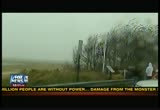
ri ngs knew to get those into protective coves so they wouldn't get wrecked. it is still possible that something has broken loose out there, but we have not seen reports. >> thank you so much. we appreciate your time this evening. i should say early this morning. it is 3:10 in the morning. >> yes, ma'am, it is. >> thank you so much. we hope you have been spared the brunt of the storm of the thank you. >> thank you very much. 16 deaths blamed on this historic storm. an estimated 5.7 million left without any power across the east coast. stay with us throughout the break for all of the latest.


3:15 am

what a night. our viewers have been sending us pictures from the middle of the storm now slamming the east coast. these photos are from new jersey. take a look. strong winds pushing over a tree on to the carve your andrew adams. that wouldn't be the only damage these branches would cause. if we zoom out, we can see another branch landing on the car next to his smashing the windows and the roof of both vehicles. a similar scene across our area as trees continue to fall. if you are in the storm's path, we want to see what you are seeing. send us your pictures or video to you report at fox news.com. as always, stay safe. >> super storm sandy has slammed into the new jersey coastline with 80 mile per hour winds and record-breaking 13-foot surge of sea water into new york city, and it has flooded the tunnels and the highways and the subway stations and the electrical systems. but you go beyond new york
3:16 am

city into some of the other states including west virginia who has been hit hard by essentially a blizzard. robert joins us now. west virginia state division homeland security and emergency management, sir what can you tell us about the conditions there? >> right now we are still running in blizzard conditions in most of the higher elevations. we have had to close down i-68 which is one of the northern connecting routes from morgantown to maryland. both muscular dystrophy muscular dystrophy -- both maryland and west virginia are closed down. parts of i-64 were closed down. we are seeing anywhere pr six inches to probably two feet in the higher elevations at this point in time. >> have you had to undertake some rescues? how are you dealing with this? >> right now we have the national guard out. it is the department of highways to try to get the
3:17 am

people off the road and get them into shelters. we do have a lot of people stranded out there. >> you know, you worry especially about the elderly and the infirmed and so forth. have you been able to make sure folks are taken care of? >> yes, sir. we had three or four days to prepare for this, our county directors in all of the counties we have been in touch with them and making sure they had everything they needed to keep track of the citizens in the county and make sure everything is going okay. we have a lot of power outages up. we are somewhere around 84, 88,000 without power. we are having people check. there are some areas that may get some flooding. they were doing evacuation in the eastern panhandle to get those people out of the flood zone. but we have been working on this for three or four days now to make sure we were ready and everybody was prepared.
3:18 am

>> any deaths or injuries ? >> we have had one confirmed death. it was an auto accident they are attributing to the storm. it was a 40-year-old female. she lost control of her vehicle in about five inches of snow and hit a concrete truck. >> but it sounds, all told, considering everything, that you have handled this pretty well. >> so far. talk together weather service people in our eoc and talking to them we still have another 24 hours of some of these blizzard conditions to look forward to. >> so given that, what's your biggest concern right now? >> power outages right now is probably our biggest concern and getting the people off the roads and into shelters. those are our two biggest things at this point in time.
3:19 am

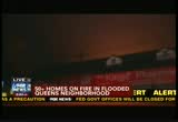
>> best of luck to you and everybody in west virginia with all of the snow and the power outages and so forth. it sounds like so far you have been pretty lucky. >> so far we have, thank you, sir. >> thank you so much. appreciate it. >> unbelievable. unto two feet of snow in -- up to two feet of snow there. and look at this, firefighters are battling a four-alarm fire. this image from the breezy point section of the rock way peninsula in queens. fire officials say the fire was reported about 11:00 p.m. monday. it involved about 15 houses. all of those houses situated in a flooded zone, an area that is flooded. a fire department spokesman says that 170 firefighters are currently at the scene. they are in breezy point. two people have suffered minor injuries. the cause of the fire not immediately known. so this is another situation. we just saw the blizzard won decisions, the hurricane-force winds, the massive flooding,
3:20 am

now fires. >> power outages. >> and power outages being reported by the ap wire associated press 6.2 million people across the east -- the u.s. east -- the eastern seaboard without power. >> it can last not only days, but maybe more than a week. we will keep on top of it and let you know the latest on that. stick with us. we will have a lot more of our live coverage of this monster storm as it moves inland. our reporters are out there braving the elements to bring you the best coverage. we'll be right back.


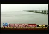
3:24 am

well, tracking hurricane sandy what was now not hurricane sandy, but still a massive storm. gary lange from the delaware emergency management office joins us now to bring us up to speed on the situation tbh -- in delaware. are you there? >> i am here. >> tell us about conditions right now. >> conditions are fairly good in delaware right now. it seems that maybe we got off a little lighter than we expected. conditions overnight and last night when we expected the high winds and the heavy rains to begin to come through the state didn't develop that way. the winds stayed light. they did not come with the intensity that were expected. >> what about any reports of injuries or deaths as a result of the storm?
3:25 am

>> no reports of that nature. we have a fair number of roads that are flooded. but it is a lengthy list, but something that we can deal with. we don't have any areas that we have had any problems with though. no deaths on the highways or in any other way. >> we have had reporters a the row -- raw rehoboth beach. he could see power -- power up in the area. how about power outages? >> some power outages across the state. we have some lines down. that was expected to occur. but again not as widespread as we might have anticipated. >> any damage estimates yet, or is that too early? >> it is way too early for that. you really can't get good damage estimates until you can get outside and take a look.
3:26 am

we need daylight for that. so they can go out once the sun comes up, take a look at some of the areas and take a look at the damage and where it occurred and exactly what occurred. >> gary, have you ever experienced any type of storm like this before? >> in terms of intensity? i immediately think of last year's hurricane irene that treated delaware more lightly than it treated our surrounding states. >> any advice for residents there this evening? and what can they expect when the sun comes up later this morning? >> the best advice we are giving now is for people to -- who say well things look good out there, and jm going to go out to the store or go out and do my normal life.
3:27 am
take a day. we have flooded roads. we have trees that are down and branches that are down on roadways. we have power lines that are down. so conditions -- there are some dangerous conditions out there across the state. if people go out too early, we could have some issues. we don't want to have that because we have come through pretty good so far. people just need to take a day, stay home, let the highway crews go out and clear the roads. let the electrical crews go out and put the lines back up and deal with those situations and not have to go out and try to rescue people who get themselves in trouble because they just went out too soon. >> gary lange joining us, and a good piece of advice for people not just in delaware, buts all across the affected state. take a day. thank you very much. recapping the very latest now from this monster storm
3:28 am

known as sandy. the system has actually lost some strength since hitting the northeast quarter. but forecasters tell us the devastation is likely to happen for several more hours and perhaps even another day. rick is standing by live at the extreme weather center. as he has been all day and all night. rick, give us an update. >> the affects of the storm will go on for probably another 24-48 hours. at least with the rain and the wind. it will be diminishing in itsen tense tee over the next 48 -- its intensity over the next 48 hours. however, it is so strong it doesn't mean it does president have a lot of ability to cause damage and power outage. have to show you this on the radar picture. the last few images. snow filling in across michigan and across parts of ohio. this is not the higher elevations. it is coming in at a lower elevation as well.
3:29 am

that's because very cold air 1* funneling in with the rapid rotation. it is bringing in the cold air from canada. the other side of the storm though is still warmer. and we have a lot of rain going on here. still some heavy rain across new jersey and in toward pennsylvania. we will continue to see the rain wrap around across -- all across areas of new england. that area tomorrow has a tornado threat. it will be in the warmer sector of the storm. they will see more showers and thunderstorms likely. some damaging winds and certainly a tornado or two are possible. here is where all of that snow has been. this is where the blizzard conditions are. blizzard warnings from maine across the mid-atlantic and back toward ohio. the storm continues to pull east. the rain is going to move off toward the east. whenwhen you see a wind map, we have high wind concerns across parts of illinois and the chicago area and down toward georgia and up across much of maine. the wind goes across much of canada as well. so such a large storm, and
3:30 am

along with that across the central appalachians. we may see areas pushing three feet of snow. because of the wind it will see some drift much larger than that. we have seen accumulating snow across parts of joe yow as well. of ohio as well. you can see the snow across areas of north carolina and tennessee and the north georgia mountains as well. guys, very big impacts from this. the biggest concern for the immediate damage is along the coastline. that's the coastline of new jersey and manhattan. i want to show you one picture. this is an area. it is right at a spit of land, the very most western p oi nt of land across areas just off of manhattan, and it is the beach area right there. it is called the rockaway, breezy point, and there are a
3:31 am

number of homes on fire. it is a five-alarm fire. they say hundreds of responders are there. you notice the town is underwater. the town is under water because the water from the ocean has breached that town. now they have a fire they are trying to get out. very interesting fact about the town. if you remember the airline that went down a couple months after 9/11, that's the town that it hit. that town was definitely hit because a lot of those were re -- first responders that died on 9/11. this kind of thing is going on in the exact same spot. a dangerous and sad situation for them. >> it really is. it really is. i don't want to throw uh curve ball, but you know the islands out near the chesapeake and the del marva peninsula, have you gotten any word on them and how they are doing? >> i have not heard anything specifically.
3:32 am

i couldn't speak to that. >> thanks very much. heather? the devastating storm of storm sandy begins to emerge. at least 16 confirmed deaths at this point. more than six million people without power. and the cost of fixing all of it, well it could climb to $20 billion. coming up, confronting the grim aftermath of this super storm.


3:35 am

time for a quick check of the headlines as this monster storm continues its march through the east. they are now -- there are now at least 16 people dead in the u.s. in weather-related incidents and an estimated 6.2 million without power. but whatever the weather, the army's third infantry regiment stands guard day and night at the tomb of the unknown at arlington national cemetery and in new york city broadway theaters will stay closed on
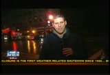
3:36 am

tuesday for a third day due to the weather. the association which runs them says it hopes to reopen on wednesday. of course the new york stock exchange closed as well. the first time in 27 years they have closed because of the weather. >> it is really quite amazing. they may be closed for days. the brunt of the super storm may be behind us, but it is no time to let up your guard. this storm is continuing to take lives. 6 teen lives so far causing all kinds of destruction hitting the coastal towns with drenching rains and punishing surf. we are going to have a better idea just how bad the destruction is. obviously it will be in the morning light. the top concern is flooding. the surge is calming down this hour in some parts. kelly wright is watching it all for us in row -- rehoboth
3:37 am

beach, delaware. >> you said something how people have to be careful because when the sun gets up they will see what kind of damage has taken place. here we can see that the surf has died down and the winds have died down, but what you eluded to is something extremely important, and i hope people are watching us or hearing us and will understand the significance of what you said, greg. that's the fact that when you see low-lying water, do not go into it. it can be deeper than what you imagine. and because of the downed trees not far from here through delaware and all along the eastern seaboard be very careful. the downed trees can have downed power lines. that's very important. those are things you can't see. that is one of the reasons a lot of power crews and even first responders are not out right now. they want to get a visual sight of what they are dealing with before they can go and help people get their power back on.
3:38 am

here in delaware there is some 35,000 people. del marva power dealing with 85,000 people without power. let me show you what happened throughout the course of the day. when the wind and waves came, it actually came all the way over here. proof is here on the ground, greg. as you look down, i will bend down, and these are pebbles from the ocean floor that i would normally pick up if i was strolling along the beach. i could actually pick those up in my land. my hand. this is all over the boardwalk. john, if you look over there, that's how they were preparing for it at the atlantic sands hotel where we are staying. you can see they have -- they have put sandbags out to protect the water from coming in. they were expecting the worst, and because they were bracing for it, they got a good surprise in not getting any significant damage whatsoever. there is no water that
3:39 am

penetrated through that. you can see the water line where it did come up right along here once again as i have said all along, they dodged the big one because when sandy came ashore it hit here, but not the way it hit cape may, atlantic city and of course as we know now new york city. so a lot of damage, but we'll find out how significant the damage is here once the day comes up and we can start assessing the damage. >> kelly wright, thanks. heather? well, among the many communities feeling the brunt of a monster storm sandy, suffolk county, new york, that coastal community located just east of new york city on the long island sound. it has been taking a pounding all nightlong. before the sun went down and as you look at these pictures, because of the storm that is
3:40 am
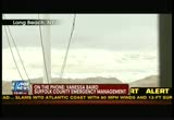
packing what meteorologists describe as astoundingly low barometric pressure and giving it terrific and terrifying energy to push it inland. we are joined by vanessa who is the suffolk county emergency management department. thank you for joining us, vanessa. >> good morning to you. >> bring us up to speed and tell us what conditions are like right now. >> the conditions that exist in sufflok county are as you noted considerable flooding. that's considerable flooding on the south shores. we are the suburban area and we have lots of trees that are intertwined with wires and intertwined with the trees. we are experiencing the power outages and flooding. >> we heard port jefferson village was under water. in terms of the flooded areas, what progress has been made there ?r -- there? >> the flooding, the water will have to recede on its
3:41 am

own. there will be another tide this morning. it wilnot be as high as the tides the last two tides. that is actually good. we will have to allow the water to recess, and then we will have our workers workers who have cleared the debris. >> what about any water rescues or stranded families you have had to assist? >> well, there was a mandatory evacuation of fire island for 2:00 p.m. on sunday. some people chose to ride it out. monday they reached out to us. we did another pro active call. there were about 14 people we had to rescue from fire island early monday afternoon. >> what about injuries or deaths to report? >> according to what i have heard and has been reported thus far, i believe we have
3:42 am

two fatalities that are associated associated -- two confirmed fatalities linked to hurricane sandy. >> so unfortunate. we heard that you in suffolk county had 1600 people in shelters? >> yes, we do. we have eight shelters open throughout the various townships on long island, and we have about 1600 people who are in those shelters. realizing a lot of time -- once the light hits, people are going to not have power and more will be attending the shelter. we also have pet shelters where pets are registered along with their owners. >> so you do still have room for people who may want to come to the shelters tomorrow? >> we do, and we will continue to assess the need. if needed we will continue to open shelters in conjunction with the american red cross. >> thank you so much for joining us. we appreciate it. hopefully the damage won't be too extensive when the comes up in a couple hours from now. thank you. >> thank you very much. getting an update now on this fire in queens, new
3:43 am

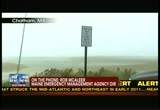
york. 15 houses are burning in this particular neighborhood. the fire department says 170 firefighters are currently at the blaze. it is in the breezy point section. we have showed pictures of this. two people suffered mien -- minor injuries and no reports of fatalities, but we will keep you posted on that. in the meantime, on monday governor martin o'malley predicted people would die in this storm, and look at these images. here is a look at what prompted the prediction. maryland is one of those east coast states that have seen the worst of sandy. the chesapeake bay is causing devastating floods especially along the beach resort of ocean city where at least a hundred feet of a fishing pier was destroyed earlier in the day. we joined by quinten banks with maryland's emergency management. thanks so much for taking a few moments. give us an update on
3:44 am

conditions there. >> well, the storm is starting to -- i don't want to say dissipate. we are still experiencing a lot in terms of wind and rain. one of our communities on maryland's eastern shore had a tidal surge of three to five feet that forced the evacuation of mean residents. we had an operation to put that into affect, but they had to break off because of the wind and the tidal surge. some of the folks had to take shelter on the second floor of the residences. we have an operation that will be starting at dawn to go rescue those folks. >> i know during the summertime the population really swells out there in ocean city. a lot of activities going on. 24r* is a beautiful boardwalk there. it is a great place to go and visits. how did that area fair?
3:45 am

>> they didn't have that many people there. that's because the mayor and the local government had encouraged the visitors as well as the residents to go to safety. they did it. they took their advice. there weren't a lot of people who suffered the impact of ocean city. >> what is your biggest concern right now? >> the wind damage and the potential for flooding when the storm is all -- is completed. >> what about rescues? have you had to undertake any? we have 1200 people in shelters right now. most are on maryland's eastern shore. we have a total of 41 shelters around the state. 37 are operated by our local jurisdictions and four are
3:46 am

operated by the state of maryland. >> the power situation? >> the power situation right now , the last figure that i saw, we lost power to 279,000 customers. >> quinten banks, maryland emergency management. best of luck to you, sir. i know at the light of day you will be surveying the damage there. we hope it is not too severe. thank you so much. >> okay. well, more than six million people are still without power. no word on when it will be back. flooded roads and downed power lines. sandy is weakening, but not letting up. a lot still in store over the next 48 hours. stick with us. we are heading back to the extreme weather center for another check with rick on this historic monster storm.


3:50 am

smie it is possible the -- it is possible the worst could be behind us. as we mentioned at the top of the hour hurricane sandy was losing strength overnight, but the system is packing powerful winds, and its mighty gusts are likely to be felt as far away as , well, chicago. can you believe that? the storm is estimated to touch 50 million people before it is all finally done. our meteorologist has the latest from the extreme weather center. hi, rick.
3:51 am
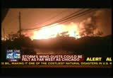
>> greg, big problems right now across parts of the new york city area. pardon the crude map that i just made up here. i made this up to show a different of a storm surge. i want to show you right here, new york city in toward manhattan and this is the new york harbor. this is why we have been dealing with the storm surge. there is a little spit of land here, a barrier island that is out here called breezy point. it is low and topped with water. now look at this picture showing the fire we have going on out there on this piece of land. it is a their restrip of land with some beautiful homes right there. and there are now 50 homes that have been destroyed by this fire according to the new york fire department. a very dangerous situation. it is now a six-alarm fire. there are over a hundred firefighters out there and having difficulty getting water. they are having to fight this with the saltwater. a big problem on their hands with 50 homes that have been now destroyed by this one home
3:52 am

-- by this one fire out there. that's obviously one concern. the broader storm continues. we have the rain going on and most of new england is in that threat. we have the colder side of the storm with such strong winds. that means the left side of the storm is bringing cold winds down. the heavy snow across the appalachians, but the snow is now filling in in columbus ohio and stretching up toward parts of michigan and we can see some accumulation right there. the biggest accumulation will be across the appalachians. the temperatures are cold behind this storm. the colder air has been moving toward the ocean, and that's what caused the storm to take on this odd not typical hurricane characteristic. but for people who were without power, they were going to have a cold night tonight. it will remain cold, and the winds will continue. look at the current wind gusts here.
3:53 am
still 52 miles an hour in harrisburg, pennsylvania. 48 in scran ton. if you go farther toward the west, 63 miles an hour right now in cleavland. 50 in detroit. 43 in chicago. it is hard to imagine we had a hurricane come on shore across parts of new jersey and the impacts are felt this far away. >> greg, the producer is telling me we have some video, the first video we are able to show you from breezy point. that fire we have on breezy point and this is the first video we are seeing of the fire going on there. i am not exactly sure what this is. there is a pharmacy right there. the fire on the other side of the building. the fire obviously to de stroit 50 homes -- to destroy 50 homes there an incredible fire and a volatile situation they are having a hard time getting a handle of.
3:54 am

>> we have been on with you for the last four hours. you have been predicting over the course of several days in fact a week what this storm would be. did it meet your predictions and expectations? did it exceed them or what? >> there are some storms -- most storms are things that if you have done this for awhile you have seen happen. you understand how they are going to happen. this was a storm that none of us had seen happen before. you had to look at what the computer models said was going to happen, and when you first started seeing this kind of a storm this strong most of us for uh -- awhile thought, that is highly unlikely to happen. the fact the computer models were really good at monitoring this storm and it really verified how we thought it would be, one of the things that is worth noting that made it easier, typically all of the weather stations send up balloons twice a day. that lets us thicial lies the models by what the weather
3:55 am

conditions are like across the country. they started sending up the weather balloons four times a day and it grave us an accurate sampling of what they were like across the u.s. it give us a better idea of what was going to happen with the storm. >> have i to ask you this, i don't recall a storm taking a trajectory like this. if are you a golfer it is like a duck clubbing. duck cluck. it was a severe turn to the left. have you seen that? >> none of us have seen it. the angle this storm came in was the worst case scenario of a storm you could see across new jersey and in toward manhattan because of the angle. that's why we have seen record storm surge in manhattan and the flooding and damage to the subway system. it is something none of us has ever seen before. a huge area of high pressure across the atlantic blocked the storm from moving toward the east and forced it back to the west.
3:56 am

as a cold front was approaching -- it is a meterological thing that people will be studying for years and years and years to see how they -- to see how this happened. >> and a full moon which brought high tides on top of it. it is truly the perfect storm. >> not only that, but the highest storm surge came in right at high tide. it was on a full moon right at the battery in lower manhattan. and that's what caused those kind of pictures of flooding. we haven't been able to show you a ton of the pictures of flooding. there are a lot floating around on twitter. twitter has sent them out. but these pictures when we wake up tomorrow morning -- well, when people are getting up and the light is on. >> when the sun comes up. rick, you have done a great job and we appreciate your coverage and taking us through it. almost a thousand miles wide. nine states are understates of emergency. it was a big one. we will see what happens when the sun comes up. >> the power outage is the
3:57 am

most painful for a great many people. we are talking about million of people without electricity, and that may last for a very longtime. there is time square, there is 6th avenue. it is pretty vacant right now. we will wait and see the total damage. >> that does it for us. i will see you on fox and friends first in about five minutes. >> bye-bye.
3:58 am

>> announcer: meet mary. she loves to shop online with her debit card, and so does bill, an identity thief who stole mary's identity, took over her bank accounts and stole her hard-earned money. now meet jack. after 40 years, he finally saved enough to enjoy retirement. angie, the waitress at jack's favorite diner, is also enjoying his retirement. with just a little information, she's opened up a credit line, draining the equity in jack's home. unfortunately, millions of americans just like you learn all it may take is a little misplaced information to wreak havoc on your life. this is identity theft, and no one helps stop it better than lifelock. see, ordinary credit monitoring
3:59 am

services tell you after your identity has been stolen. they may take 30 days to alert you-- too late for jack. lifelock has the most comprehensive identity theft protection available. if mary had lifelock's bank account alerts, she may have been notified in time to help stop it. if jack had lifelock's 24/7 proactive protection, he could have been alerted by phone or e-mail as soon as they noticed an attack on their network, before it was too late. lifelock has the most comprehensive identity theft protection available, guarding your social security number, your money, your credit, even the equity in your home. while identity theft can't be completely stopped, no one works harder to protect you than lifelock. you even get a $1 million service guarantee. that's security no one can beat. you have so much to protect and nothing to lose when you call lifelock right now and get 60 days of identity theft protection risk free-- that's right, 60 days risk free-- use promo code: notme. order now and get this document shredder to keep sensitive
222 Views
IN COLLECTIONS
Fox News Television Archive
  Television Archive News Search Service
Uploaded by TV Archive on
